Survey Applications

Remote Sensing is a fresh and complex detection technology in the 1960s, which is formed and developed gradually to a new inter discipline with the development of SpaceTechnology, Information Technology, Electronic Computer Technology and Environmental Sciences.

Land resource investigation

A large number of arduous and dangerous surveying and mapping work can be done by drones to replace the traditional way by three-dimensional surveying.

Emergency rescue surveying

Quickly acquire the topographic map and current situation in disaster area to form DOM, DSM digital image and digital data model.

Marine resources survey

No need for landing islands to get high-resolution high-resolution aerial photograph data.

Military mapping

Quickly get the complete information of topography, landform and surface appendages, to provide information winning the war.

Water resources investigation

Manage canal, water and soil resource on both sides of the river and surrounding lakes, and detect illegal activities and construction projects.

Project Application

Scanning the original appearance of the project to facilitate the construction of special operations can be combined with historical data for project management and control.

Case Study

We have rich experience on oblique imaging and model, which helps us obtain high customer recognition in various industries.

Island oblique image data of antique buildings

Oblique image data of antique buildings

Oblique image data of antique buildings

Oblique image model for new district

Oblique image model for houses

Ortho image / numeric model in mountainous area

Powerful Control Software

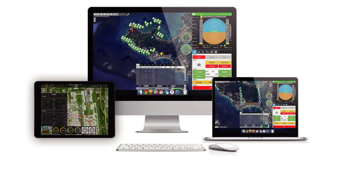
Support multi- and cross- platform usage. Loading multiple satellite maps for route planning

PAYLOADS

The main payloads of UAV to deal with mapping or surveying service are as followings:

Single lens ortho camera

Multi lens oblique camera

Laser radar

Recommended UAV Platform

TTA has a variety of UAV platforms to support  aerial surveying in different environment, with a more efficient and reliable operation.

Related Videos

The below demo video will provide you with an overview of our most popular product features- you can also learn more by visiting our website.

TTA Aerial Mapping UAV Solution

TTA UAV is designed for aerial photography, surveying and mapping, wiring,security, logistics. It support intelligent course flight and could carry different kinds of special devices to meet different demands. The UAV have been tested thousands of times and it won the approval of the market for years through real flying experiments. And it got the praise and trust of different industrial field customers.

TTA Mapping UAV

TTA Mapping solution uses with cameras, RADAR, and hyperspectral sensors on UAV’s for highly-efficient, automated mapping and surveying. We design fixed wing and multi-rotor surveying drones to operate the sensor to your specifications.

2018 TTA all rights reserved | Privacy protection | Legal